File:Belgiumlux.png
Jump to navigation
Jump to search

Size of this preview: 749 × 600 pixels. Other resolutions: 300 × 240 pixels | 600 × 480 pixels | 959 × 768 pixels | 1,118 × 895 pixels.
Original file (1,118 × 895 pixels, file size: 135 KB, MIME type: image/png)
| Description |
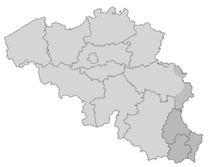
English: Map of the old districts in the Grand Duchy of Luxembourg. Nederlands: Kaart van de kantons in het Groothertogdom Luxemburg. Français : Carte des anciens districts du Grand-Duché de Luxembourg.
English: Wallonia with its five provinces. Français : Carte de Wallonie avec ses cinq provinces. Nederlands: Wallonië met zijn vijf provincies.
English: Map of Flanders with its five provinces. Français : Carte de Flandre avec ses cinq provinces. Nederlands: Kaart van Vlaanderen met zijn vijf provincies. |
| Date | (UTC) |
| Source | |
| Author | |
| Permission (Reusing this file) |
CC 3.0 Unported, CC 2.5 Algemeen, CC 2.0 Algemeen en CC 1.0 Algemeen. |
.png)
| This is a retouched picture, which means that it has been digitally altered from its original version. Modifications: Making one map, new lines for Luxembourg. The original can be viewed here: Provinces of Flanders.svg:
|
This file is licensed under the Creative Commons Attribution-Share Alike 3.0 Unported license.
- You are free:
- to share – to copy, distribute and transmit the work
- to remix – to adapt the work
- Under the following conditions:
- attribution – You must give appropriate credit, provide a link to the license, and indicate if changes were made. You may do so in any reasonable manner, but not in any way that suggests the licensor endorses you or your use.
- share alike – If you remix, transform, or build upon the material, you must distribute your contributions under the same or compatible license as the original.
Original upload log
This image is a derivative work of the following images:
- File:Groothertogdom_LuxemburgKantons_(nieuw).png licensed with PD-self
- 2008-09-15T15:35:30Z Maarten 203x270 (5426 Bytes) {{Information |Description={{en|1=Map of the cantons in the Grand Duchy of Luxembourg.}} {{nl|1=Kaart van de kantons in het Groothertogdom Luxemburg.}} |Source=eigen werk (own work) |Author=[[User:Maarten|Maarten Smit]] |Date
- File:Provinces_of_Wallonia.svg licensed with Cc-by-sa-3.0,2.5,2.0,1.0, GFDL
- 2010-11-23T00:01:03Z SPQRobin 938x544 (19158 Bytes) == {{int:filedesc}} == {{Information |Description={{en|1=Wallonia with its five provinces.}} {{nl|1=Wallonië met zijn vijf provincies.}} |Source=Based on [[:File:Belgique vierge.svg]] |Author=[[User:Vascer]] and [[User:
- File:Provinces_of_Flanders.svg licensed with Cc-by-sa-3.0,2.5,2.0,1.0, GFDL
- 2010-11-22T23:56:47Z SPQRobin 879x341 (17808 Bytes) == {{int:filedesc}} == {{Information |Description={{en|1=Map of Flanders with its five provinces.}} {{nl|1=Kaart van Vlaanderen met zijn vijf provincies.}} |Source=Based on [[:File:Belgique vierge.svg]] |Author=[[User:Va
Uploaded with derivativeFX
File history
Click on a date/time to view the file as it appeared at that time.
| Date/Time | Thumbnail | Dimensions | User | Comment | |
|---|---|---|---|---|---|
| current | 14:20, 9 August 2011 | | 1,118 × 895 (135 KB) | Smile4ever | Transparent space reduced (to much white) |
| 14:15, 9 August 2011 |  | 2,262 × 1,767 (153 KB) | Smile4ever | {{Information |Description={{en|Map of the cantons in the Grand Duchy of Luxembourg.}} {{nl|Kaart van de kantons in het Groothertogdom Luxemburg.}} {{fr|Carte des cantons du [[:fr:Grand-Duché de Luxembourg|Gran |
File usage
The following 5 pages use this file:
Global file usage
The following other wikis use this file:
- Usage on nl.wikipedia.org
- Wikipedia:Wikiproject/Erfgoed/Belgische Erfgoedinventarisatie/Website
- Wikipedia:Wikiproject/Erfgoed/Belgische Erfgoedinventarisatie/Website/Actueel
- Wikipedia:Wikiproject/Erfgoed/Belgische Erfgoedinventarisatie/Website/État actuel
- Wikipedia:Wikiproject/Erfgoed/Belgische Erfgoedinventarisatie/Website/Current status
- Wikipedia:Wikiproject/Erfgoed/Belgische Erfgoedinventarisatie/Website/Aktuell
- Wikipedia:Wikiproject/Erfgoed/Belgische Erfgoedinventarisatie/Website/Introduction-LB
- Wikipedia:Wikiproject/Erfgoed/Belgische Erfgoedinventarisatie/Website/Aktuelle Status